
SCIENCE CITY
INFRASTRUCTURE AS LANDSCAPE
PROJECT STATUS | COMPLETED
PROJECT OVERVIEW
Science City is envisioned as a 24/7 research hub developed by the Puerto Rico Science, Technology and Research Trust on the site of a former state prison. Based on a 2007 Master Plan by James Corner Field Operations with ArchUd and Toro Ferrer Architects, the project reimagines the grounds as a world-class center for innovation. In 2009, Vaccarino Associates joined Toro Arquitectos to assist from conceptual design through construction documents for two key urban corridors—Science City Boulevard and Laboratory Street. The project received the XIII Bienal de Arquitectura y Arquitectura Paisajista Honor Award in 2010 in the Unbuilt Project category.
REGIONAL OVERVIEW
Science City lies at the center of the Knowledge Corridor, a 2,000-acre district in metropolitan San Juan envisioned in the 2007 Master Plan to drive economic growth through Puerto Rico’s expanding life sciences sector. The plan sought to activate underutilized land by leveraging institutional anchors and transit infrastructure, creating a framework for urban regeneration at multiple scales.
Within this vision, the idea of Landscape as Infrastructure and Infrastructure as Landscape shapes the open space and Puerto Rico stormwater management strategies developed in parallel with the Comprehensive Cancer Center.
THE KNOWLEDGE CORRIDOR
Anchored along the Tren Urbano between Piñero and San Francisco stations, the Knowledge Corridor leverages major institutional tenants as catalysts for growth. The 2007 Master Plan identifies more than 25 development and redevelopment opportunities within this framework.
THE SITE AND ITS LINKAGES
At the heart of the Knowledge Corridor, Science City occupies an 81-acre publicly held site within a 12-minute walk of two Tren Urbano stations. A proposed shuttle loop, along with pedestrian and bicycle circuits, connects the stations to Science City and links its three campuses into a cohesive, transit-oriented development. This framework demonstrates the role of landscape architecture design in shaping resilient, interconnected, and accessible infrastructure for the city.
THE URBAN CHALLENGE
Multifunctional urban corridors serve both people and vehicles, while trees provide shade, clean air, cooler streets, and livable public space. Yet urban trees often fail to thrive because of how we build. The most significant challenge is soil compaction beneath impermeable pavement, engineered for load-bearing rather than life-support.
Other barriers include poor soil nutrients, limited water, root damage from construction, and insufficient maintenance. When roots encounter dense soil, they turn, stop growing, or remain near the surface in search of oxygen—making trees more vulnerable to drought and causing sidewalks to crack. If we expect resilient communities, we must invest in new ways to plant and manage urban forests as essential infrastructure.

GREEN BELOW GROUND
This project addresses the conflict between root growth and the underground systems that support pavement, utilities, drainage, and stormwater. It redefines the ground plane not as a barrier but as shared space, where green and blue infrastructure above and below functions together.
Traditionally, the urban surface has been treated as a thin datum separating soil from city. Here, it expands to encompass both realms—roots and infrastructure—acknowledging their interdependence. With shrinking municipal budgets for tree care, it is more efficient to respect the natural branching of each species and invest in proper soil and stormwater management systems at planting. The goal is to create resilient landscapes not through constant pruning but by designing underground conditions that allow trees to grow strong from the start.
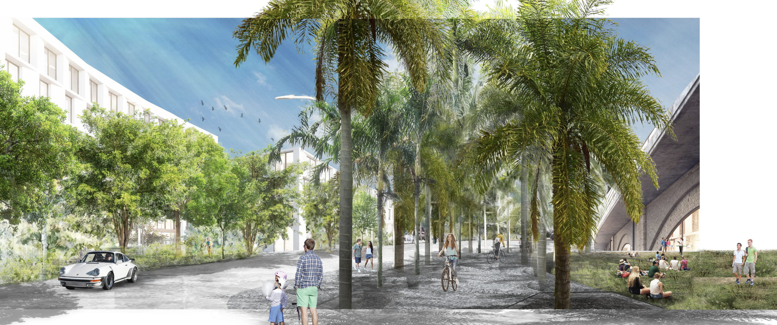
THE SAMAN BOULEVARD
The Saman Boulevard demonstrates that large trees can be engineered into sidewalks to create dignified urban spaces where none exist today. It stands as a manifesto against ordinances and utility practices that limit cities to small, scattered trees in the name of reduced maintenance.
Trees thrive—and withstand hurricanes—when grown close together, their branches and roots interwoven as in natural habitats. The Saman Boulevard is not a nostalgic return to the past but a call to reintroduce large, continuous plantings as the backbone of urban districts. Here, trees are not ornamental additions but integral infrastructure, planned alongside roads, sidewalks, and utilities to shape the city’s form and function.
THE UNNATURAL FOREST
Samanea saman, a drought-tolerant and long-lived tree, has long been used for tropical avenue plantings. In Puerto Rico and Vieques, it thrives in disturbed areas and savannas. With space for its roots—as provided under the cantilevered planks—it develops 80-foot umbrella crowns that span multiple driving lanes, transforming what functions as a four-lane highway into the form of a shaded urban boulevard.
Planting a single species in tight rhythm produces a continuous canopy, a syncopated pattern of light and shade that slows perception and unifies space. This is critical in Science City, where the urban fabric is still emerging and boundaries remain open. By contrast, mixing species in random order fails to recreate the richness of a natural forest, which depends on complex ecological dynamics. Paradoxically, it is the ordered repetition of one species—closely spaced and interwoven—that evokes the immersive experience of a forest, even in the middle of the city.
WOODLAND EDGES: TRANSITIONAL LANDSCAPES
Laboratory Street functions as an urban ecotone—a transitional zone where contrasting programs and site conditions converge. Unlike the unified and symmetrical space of Saman Boulevard, its character is defined by asymmetry, with each edge taking precedence over the center. One side anticipates dense office development, the other a future park. This tension between built form and open space frames the identity of the street.
On the office side, rows of trees structure sidewalks and parking, providing shade and rhythm along the façade line. On the park side, planting is transparent and porous, preserving long views into open space. Environmental factors—sun exposure, moisture, and wind—reinforce this duality, requiring a sharp transition in vegetation. Laboratory Street is not about spatial uniformity but about negotiation, embracing utility, mobility, and the shifting experiences between city and landscape.
THE PALM WOODLAND EDGE
On the park side of Laboratory Street, three palm species—Roystonea borinquena, Acrocomia media, and Carpentaria acuminata—are planted densely in a linear grove. Their alternating arrangement defines the bike path, while trapezoidal flush planters create jagged edges that add rhythm and energy to the ride.
Above, overlapping pinnate leaves produce a layered canopy of shifting textures and light. We specified staggered sizes at planting to achieve height variation: Royals towering above Carpentarias, with Acrocomias holding the middle. Over time, as Carpentarias grow to rival the Royals, the contrast will shift from leaf structure to trunk form, ensuring the woodland edge remains dynamic and visually engaging even at maturity.

THE TREE WOODLAND EDGE
The name given to this landscape typology is figurative rather than literal: it does not mimic a natural woodland edge, but instead creates a partial “reforestation” of the sidewalk with diverse species adapted to drought, confinement, and poor soils—conditions improved here through careful soil and drainage design.
Trees provide a buffer against noise, pollution, and traffic, while giving shade and scale to the narrow sidewalk alongside tall office buildings. Planting focuses on texture and tonal variations of green rather than flowers or showy forms, purposefully crowding smaller trees with larger ones to accelerate canopy formation. Species selection prioritizes resilient natives proven in Puerto Rico’s urban conditions, even as the island’s urban forest remains dominated by exotic and naturalized species.
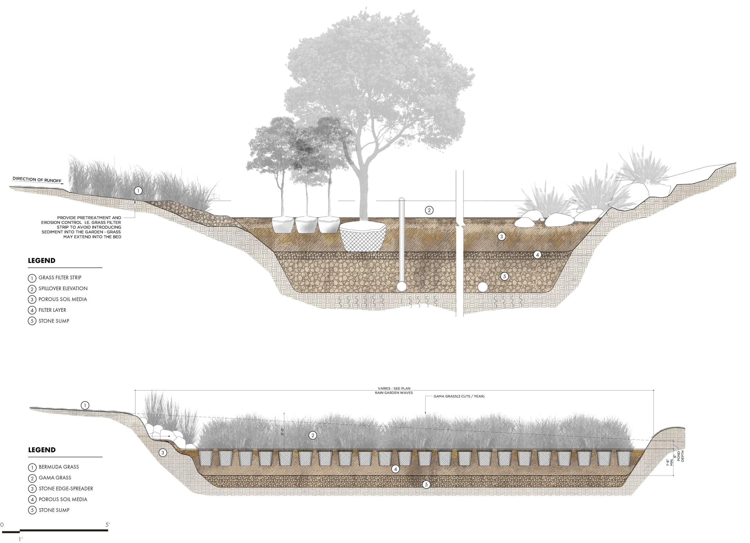
THE FLOOD CONTROL PARTERRE
In classical Italian and French gardens, the parterre was a decorative ground plane of clipped hedges, gravel, and flowers. Here, it is reinterpreted with ecological purpose—as an underground system for water harvesting and storage. Using Tripsacum floridiana and Tripsacum dactyloides, resilient grasses that thrive in both drought and flood, the design turns pattern into infrastructure.
At the nearby Comprehensive Cancer Center, we arranged these grasses in alternating ribbons across a Bermuda grass field: the shorter species on higher ground, the taller in the low points. Acting like natural weirs, the rows of grasses slow and capture stormwater, their roots intercepting runoff and reducing erosion. This living parterre eliminates the need for oversized drainage systems while adding a dynamic texture to the landscape.
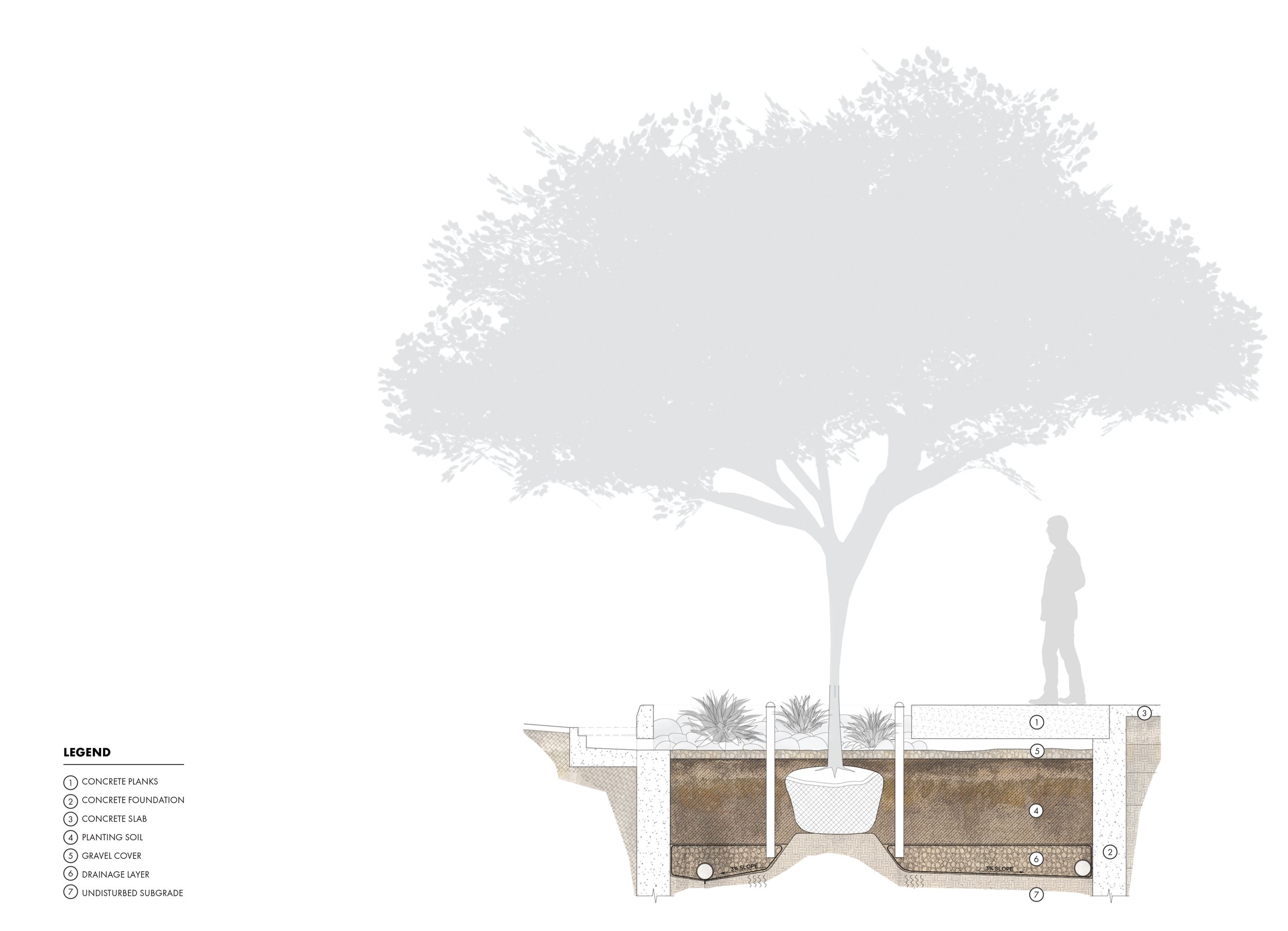
CANTILEVERED PLANKS
Along Saman Boulevard, sidewalks are conceived as spanning deck surfaces: prefabricated concrete planks laid like oversized wood boards. This approach avoids soil compaction during construction, while gaps between planks allow stormwater infiltration, tree irrigation, and even liquid compost applications to sustain growth over time.
A large volume of uncompacted soil is provided for the roots of the Samanea saman trees to expand freely. Beneath, a stormwater trench recreates the permeable conditions of natural landscapes, filtering and storing runoff to sustain the trees. Roadway water will enter through curb openings, feeding the root system before reaching the stormwater network.
PERVIOUS OVER STRUCTURAL SOIL
The underground strategy at Laboratory Street contrasts with Saman Boulevard. Instead of suspending sidewalks to protect uncompacted soil, here the soil itself is “suspended” within a matrix of angular crushed stone—maintaining both porosity for roots and structural strength for load-bearing pavement.
This system uses CU-Structural Soil beneath pervious concrete paving, which is made of small aggregate and cement without sand. The crushed stone forms a rigid skeleton compacted to engineering standards, while the soil in the voids supports root growth. Palm roots interlace through this medium, anchoring the trees and stabilizing them even during heavy storms.
In our woodland edge approach, structural soil and drainage beneath pervious pavement allow native species to thrive. Sustaining urban trees is a complex, engineered practice—costly unless renewable sources are used for planting soils. By crowding smaller trees with larger ones, we create an immediate, dramatic transformation with the largest sizes available.

VEGETATED INFILTRATION SUMP
Often called a bioretention cell or rain garden, this stormwater design approach is a planted trench or depression filled with permeable soil and drainage layers. It slows surface runoff from surrounding paved areas, reduces erosion, and recharges the aquifer.
While most rain gardens emphasize only function—informal depressions with drought-tolerant, flood-adapted plants—Science City also treats them as design elements. Here, the infiltration sumps form a drifting, repetitive pattern, recalling a parterre, and mark the entrances to Saman Boulevard with a distinctive identity.
All Photographs © Rossana Vaccarino Except Where Noted.
© All Rights Reserved. No Part Of This Publication. Total Or Partial, May Be Reproduced, Distributed, Or Transmitted In Any Form Or By Any Means. Including Photocopying, Recording, Electronic Or Mechanical Methods Or Other Means Is Strictly Prohibited Without Written Permission.